|
|
|
|
|
|
| |
 |
| Click On The Image For Larger View |
|
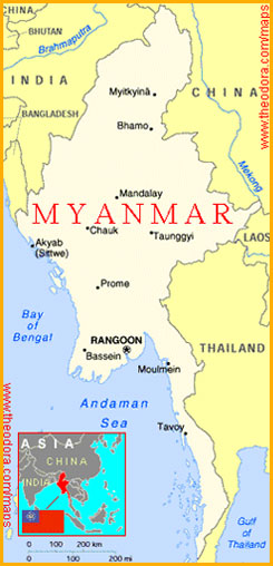
MYANMAR (Burma)
U.S.S.A. member country Burma is known as Myanmar since 1989. Most of the people in Myanmar are Buddhists. A special feature of the religious places here is the high tapering domes. These places of worship are known as ‘Pagodas’. Pagodas are seen all over the country and so Myanmar is called the ‘Land of Pagodas’. In climate and culture, Mayanmar is very like India. |
| Location, extent and boundaries |
Myanmar lies in South-east Asia. It extends from 10 degrees N to 28 degrees N latitude and from 92 degrees E to 101 degrees E Longitude. The total area of the country is nearly 6 lakhs 76 thousand square kilometers. To the east of Myanmar lie Thailand and Loas,and to the north, China. The Indian Ocean lies to the south. To the west lie the Bay of Bengal, Bangladesh and India. |
| Physical features |
The northern part of Myanmar is mountainous and hilly. The eastern ranges of Himalayas spread in Myanmar. The altitude of these ranges decrease towards the south. The peak of Khakhaporazi near the Chinese boarder in the north has an altitude of 5887 metres. The rakhine ( Arakan ) Yoma lies in western part. ‘Yoma’ means a mountain. The Pegu Yoma range runs north-south in Myanmar. The eastern part of Myanmar consists of an extensive plateau. The height of this plateau is 100 to 1200 meters. This region is known as the ‘Shan Plateau’. Some part of this coastal strip and the deltas near the mouths of the rivers are plains. |
| Rivers |
The Irrawatty is the biggest river in Myanmar. The Chindwin river is a tributary of the Irrawatty. The river Irrawatty is useful for irrigation and also as a waterway. There is a delta region near the mouth of the Irrawatty. The Salween and Sittang are the other important rivers in Myanmar. The rivers in Myanmar flow southwards. |
| Climate |
Myanmar has a monsoon type climate. The climate in the coastal regions is hot and humid. The range of temperatures is wide in the plains. But the climate in the high mountains north is usually cool. The maximum temperature in Myanmar is 29 degrees C and the minimum is 20 degrees C. Rains are received from the south-west monsoon winds. The coastal region receives heavy rainfall. The rainfall in this region is nearly 260 cm. The rainfall on the plateau is around 80 cm. The rainfall increases towards the northern hilly regions. The average annual rainfall of Myanmar is 100 cm. |
| Vegetation and animal life |
More than half of the country’s total area is occupied by forest. There are many teak trees in these forests. The number of forests is greater in the high altitude regions. Evergreen and deciduous forests are found in the regions with a hot climate. The trees found in these forests are teak, khair, bamboo,coconut,mango, jackfruit,plam etc. The teak from Myanmar is of the best quality and there is a demand for it from all over the world. Forests of ‘Sundri’ trees are found in the delta regions near the mouths of the rivers. Rubber trees grow in the Tenasserim region. Because of cutting down of the trees, the forests on the Shan Plateau are getting depleted. Animals such as tigers,leopards,bisons,elephants,deer, monkeys, etc. are found in the forests. Rhino with two horns are found in the forests in the north. Pythons,snakes, turtles, alligators are found in the delta regions. The birds of Myanmar are the partridge, peacock, wild fowl, parrot etc. The elephant is a very important animal in this country. It is useful for transportation logs of wood. There is large number of buffaloes and pigs in the country. |
| Mineral wealth and energy resources |
Myanmar is rich in minerals. Mineral oil is found in the central part of the Irrawatty valley. Precious stones such as sapphires emeralds, rubies etc. are found in the Shan Plateau. Myanmar is famous for jades. There are lead, ,silver and zinc mines in some parts of Myanmar. There are tin and tungsten mines in the Tenasserim regions. Pearls are found in the Gulf of Martaban. Mineral oil and natural gas are as energy resources. Coal is used for the generation of thermal electricity. There are hydro-electric plants at Lapita, Loikaw and Tekai. |
| Agriculture |
Myanmar is one of the leading rice producing countries of the world. Other crops that grow in Myanmar are groundnut,jute,sesame,sugarcane,cotton,tobacco, wheat, maize,soyabean etc. There are tea plantations on the shan Plateau. There are orchards of fruits like pineapples, bananas, oranges, coconuts, betel nuts etc. in the coastal region. Large scale rubber plantations are seen on the Tenasserim coast. |
| Industries and occupations |
The main occupation of the people is agriculture. Rearing cattle is an important occupation in the grasslands. Fishing and Lumbering are also important occupations. Lumbering is done mainly in summer. Logs float down to the coastal region with the flood water in monsoon. These logs are then sent to the saw-mills. Cutting of wood is carried on in the coastal region. Securities or feeding silk-worms on mulberry leaves and then taking out the silk thread is another occupation. New industries are now coming up in Myanmar. Industries such as cotton yarn and textile industry, jute mill, steel industry are gaining importance. |
| Transport and communications |
Railways, waterways and roadways are the chief modes of transport in Myanmar. Airways are also being used now-a-days. The Irrawatty is very useful as a waterways in the deep interior of Myanmar. The Chindwin and Sittang rivers are also useful as waterways. There are sea-routes along the coastal regions. Yangon is a port in the Irrawatty delta. All the main roads and railways run north-south in Myanmar. All major cities are connected by roads and railways. As there are inaccessible mountains, thick forest s and valleys between India and Myanmar, there are very few transport routes across this terrain. Transport between these two countries, therefore, is mainly by air or by sea. Yangon is a centre of transport.
There is an international airport at Yangon.
The radio and television network has spread throughout the country. |
| Trade |
Myanmar exports rice, teak, timber, mineral oil, rubber etc. the goods imported include machinery, medicines, textiles, vehicles, building materials. |
| Human Life |
The population of Myanmar is nearly four crores. The people of Myanmar mainly belong to the Mongolian race and are Buddhists. Their main language is Burmese but English is also widely used. The staple food of the people in Myanmar is rice and fish. Tea is the favorite beverage. The people in Myanmar dress is a ‘lungi’, a shirt and a colored silk scarf round their head. Women also dress in the same fashion. All the people like bright colorful dresses with intricate designs. Women carry a multi-coloured fan and as umbrella with beautiful designs
The houses are made mostly of wood and bamboo, and have a thatched roof of Palm-leaves. Houses are built at a height above the ground, on wooden poles in the marshlands. Modern buildings can be seen in the cities. These people are very fond of games, dancing and acting. Football is their favorite game. |
|
|
|
|
| Major cities and towns : |
| Yangon (Rangoon) |
This important city in the delta region is the capital of the country. All trade of the country is carried on through Yangon as it is a big port. There are rice mills, oil refineries, saw-mills and market places in Yangon. It is also an educational centre. The Shwe Dagon Pagoda here is very famous. Yangon is a very important tourist centre. |
| Mandalay |
This city is situated on the banks of the river Irrawatty. It was the ancient capital of Myanmar. Ruins of many ancient buildings can be seen here. The Pagoda at Mandalay is considered very sacred by the Buddhists. |
| Akyab |
Akyab is a port. It is close to India by air and by sea. Aero planes on the Calcutta - Yangon route halt at Akyab. |
| Moulmein |
This city lies in the Gulf of Martaban and exports teak-wood on a large scale. |
| Tavoy |
Tavoy is a port on the Tenasserim coast. It handles trade in tin, tungsten and rubber. |
| Social Unit |
The people of Myanmar believe in marriage and in the concept of livening together in a family. The bride is adorned with jewellery and Mehndi at the time of the marriage. Music and dance is highly valued and appreciated. |
|
|
|
|
| STATISTICS OF MYANMAR (Burma) (Source World Atlas) |
| Area |
Total area: 678,500sq. km slightly smaller than Texas.
Land area: 657,740 sq.km. |
| Natural Resources |
Petroleum, timber, tin, antimony, zinc, copper, tungsten, lead, coal, some marble, limestone, precious stones, natural gas. |
| Land Use |
• Arable land : 15%.
• Permanent crops: 1%.
• Meadows and pastures: 1%.
• Forest and woodland : 49%.
• Other: 34%. |
| Irrigated Land |
10,180 sq. km (1989). |
| People |
| Population |
45,103,809 ( July 1995 est.) |
| Age Structure (0-14) Yrs |
36% (female 7,963,544; male 8,285,459) |
| Age Structure (15-64) Yrs |
60% (female 13,478,211; male 13,404,987) |
| 65 Years and over |
4% (female 1,080,922; male 890,686) (July 1995 est.) |
| Population Growth Rate |
1.84 % (1995 est.) |
|
| Literacy |
Age 15 and over who can read and write (1990 est.)
Total population: 81%.
Male: 89%.
Female: 72%. |
| Labor Force |
| 16.007 million (1992) |
| By occupation |
| Agriculture |
65.2% |
| Industry |
14.3%. |
| Trade |
10.1%. |
| Government |
6.3 % |
| Other |
(FY88/89 est ). |
|
| National Product-GDP |
purchasing power parity-$41.4 billion (1994 est.) |
| National Product-Real Growth Rate |
6.4 % (1994). |
| National Product-Per Capita |
$ 930 (1994 est. ) |
| Budget |
Revenues: $ 4.4 billion.
Expenditures: $ 6.7 billion, including capital expenditures of NY ( FY 93/ 94 est.). |
| Exports |
$ 674 million ( FY 93/94 est.)
Commodities: -Pulses and beans, teak, rice, hardwood. |
| Imports |
$ 1.2 billion ( FY 93/94 est. )
Commodities: -Machinery, transport equipment, chemicals, food products. |
| Industrial Production |
Growth Rate 4.9% ( FY 92/93 est..); account for 10% of GDP. |
| Agriculture |
Accounts for 65% ogf GDP and 65% of employment (including fishing, animal husbandry, and forestry) ; self-sufficient in food; principal crops – paddy rice, corn, oilseed, sugarcane, pulses; world’s largest stand of hardwood trees; rice and timber account for 55% of export revenues. |
| TRANSPORTATION |
| Railroad |
Total: 3,991 km (3,878 km common carrier lines, 113 km industrial lines).
Standard gauge: 3,878 km 1.4345 – m gauge.
Other: 113 km NA-m gauge. |
| Highways |
Total :-27,000 km.
Paved: bituminous 3,200 km.
Unpaved: gravel, imported earth 17,700 km; unimproved earth 6,100 km. |
| Inland Waterways |
12,800 km; 3,200 km navigable by large commercial vessels. |
| Pipelines |
Crude oil 1,343 km; natural gas 330 km. |
| Ports |
Bassein, Bhamo, Chauk, Mandalay, Moulmein, Myitkyina, Rangoon, Sittwe, Tavoy. |
| Merchant Mines |
Total :-49 ships (1,000 GRT or over) totaling 638,297 GRT/ 884, 492 DWT. Ships by type : bulk 19, cargo 15, chemical tanker 1, container 2, oil tanker 3, passenger – cargo 3, refrigerated cargo 4, vehicle carrier 2. |
| Airports |
Total: 80 ·
With paved runways over 3,047 m: 2.
With paved runways 2,438 to 3,047 m : 2.
With paved runways 1,524 to 2,437 m: 10.
With paved runways 1,523 m: 11
With paved runways under 914 m: 33
With unpaved runways 1,524 to 2,438 m: 5
With paved runways 914 to 1,523 m: 17 |
|
| COMMUNICATIONS |
| Telephone Systems |
53,000 telephones (1986) ; meets minimum requirements for local intercity service for business and government; international service is good.
Local: NA
Intercity: NA.
International : 1 INTELSAT (Indian Ocean) earth station. |
| Radio |
Broadcast stations:
AM 2,
FM 1,
shortwave 0 (1985).
Radios: NA
Note: Radiobroadcast coverage is limited to the most populous areas. |
| Television |
Broadcast stations: 1(1985).
Televisions: NA. |
|
| Manpower Availability |
Males age ( 15-49) 11,553,094; female age (15-49) 11, 463,189;
Males Fit for Military Service 6,180,091; Females Fit for Military Service 6,116,421;
Males Reach Military age (18) Annually 457,445 ( 1995 est. );
Females reach military age (18) Annually 441,628 ( 1995 est.)
Note: Both sexes are liable for military service. |
|
| Note : NA = Information not available. FY = Financial Year. |
| ^TOP |
|
|
| |
|
|
|
|
|