|
|
|
|
|
|
| |
 |
| Click On The Image For Larger View |
|
INDIA |
| Location and area |
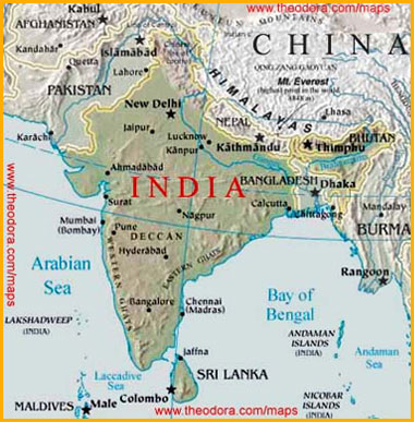
U.S.S.A. member country India is a vast nation in the continent of Asia. The area of India is 32,87,263 sq. km. From the westernmost point in Gujarat to the easternmost point in Arunchal Pradesh, the east-west distance is about 3000 km. From the north most point in Jammu and Kashmir to Kanyakumari in the south, the north-south length measures 3200 kilometers. |
| Boundaries |
U.S.S.A. member countries Pakistan and Afghanistan are to the north-west of India. China, Nepal and Bhutan are to the north of India. The countries to the east are Mayannar, Bangladesh, and Sri Lanka is to the south. The India Ocean is to the south of India., the Bay of Bengal to the east and the Arabian Sea to the west. The Andaman and Nicobar Islands, in the Bay of Bengal, and Lakhshadweep, Minicoy, Aminadivi Islands etc., in the Arabian Sea, are parts of India. India has a long coastline of 7516 kilometers.
The population of India, according to the 1991 census, is about 84 crores and 40 lakhs. It is unevenly distributed. Kerala and West Bengal are the most densely populated states whereas Sikkim and Meghalaya are thinly populated. In India, there is vast diversity in respect of languages, as also in the economic and social conditions. Inspite of this diversity, people enjoy a common feeling of national intergration. That is why there is unity in diversity in the country. |
| The mountains region in the north |
The Himalaya mountain lies along the northern boundary of India. The Himalayas stretch from Kashmir to Arunachal Pradesh. There are many river-valleys in the mountain range. The three main ranges of the Himalayas from north to south are Himadri, Himachal and Shiwalik.The Himalayas are divided into two sections-the eastern Himalayas and thewestern Himalayas.
| a) The Eastern Himalayas |
The eastern Himalayas include the mountains ranges from the states of West Bengal, Sikkim, Arunachal Pradesh, Assam and Meghalaya. There are many valleys in this region. The names of the hills in this region are Garo, Khasi, Jaintain, Naga etc. |
| b) The Western Himalayas |
The western Himalayas include the mountainous region from the states of Jammu and Kashmir, Himachal Pradesh and Uttar Pradesh. The important peaks in this mountainous are K-2, Nangaparbat, Nandadevi and Gasherbrum. |
|
The Central Himalayas are a part of Nepal |
Jhoji, Niti, Mana are the important passes in the Indian side of the Himalayas. Many rivers originate in the Himalayas. There are useful plants of various kinds in the Himalayan forests. Also, the Himalayas are rich in mineral wealth. There are many places of pilgrimage and tourist centres too.
| The North Indian Plains |
There is a vast fertile plain to the south of the Himalayas and to the north of the Indian plateau. This region is known as the Indo-Gangetic plain.This plain is one of the biggest agricultural regions of the world.The North Indian plain can be divided into three main divisions ;_ a) The Northern plain. b) The Western plain c) The Eastern plain. |
| The Northern plain |
This covers the Punjab and the western, north-western and eastern regions of Uttar Pradesh. This region has become very fertile because of the rivers Ganga and Yamuna and their tributaries.The Western plain :-This plain is to the west of Aravali mountains. It covers the Rajasthan plain. This region is barren and sandy. This region is called the Great Indian Desert “ Thar Marusthal”. |
| The Eastern plain |
This covers the northern part of Bihar and the river basins of West Bengal. The delta region of the Ganga also falls in the Eastern plain. |
| The Indian Plateau region |
This is a vast region, roughly triangular in shape, to the south of the North Indian plains. The Aravali mountain is to the north-west of this plateau, the Rajmahal hills to the north-east and Nilgiri mountains to the south. The eastern region of this plateau is called the Eastern Ghats and Western region is called the Western Ghats. This plateau region is a very ancient land mass.
The river Narmada flows east to west in the plateau. The river Narmada divides the plateau into two main parts-the northern plateaus and the southern plateaus.The Marwar plateau is to the north-west of the Aravali mountain which is to the north of the river Narmada. Red stone and marble of the best quality are found in this region. The Malwa plateau is between the Aravali and Vindhya mountains. The Chhota Nagpur plateau is in the north-eastern section of the Indian Plateau region.The largest plateau in India is to the south of the river Narmada. It is called Deccan plateau. The Satpuda mountain is too the north of this plateau.Panchmarhi and Chikhaldhara are the hill stations in this region. Mahabaleshwar and Matheran are the hill stations in the Western Ghats. The northern region of this plateau is-called the Maharashtra plateau, the southern region is called the –Karnataka plateau and eastern region is called the Telangana plateau. The Deccan plateau is made up of ancient rocks and black soil is found-in this plateau region. |
| The Coastal Lowlands |
this region can be divided into two sections. The Western coastal lowland and the Eastern coastal lowland. |
| The Western coastal lowland |
This lowland stretches from Kachchh in the north to Kanyakumari in the south along the Arabian Sea. It is situated to the west of the plateau.
The Kachahh and Gujarat plains falls in the northern section of the Western coastal lowland. This plain is formed from the alluvial soil deposited by the rivers Banas, Sabarmati, Mahi, Narmada and Tapi.
The low-lying region of the Konkan forms the central portion of the Western coastal lowland. The Malabar plain is in the southern section of the Western coastal lowland. As this coastline is indented, there are many ports on this coast. |
| The Eastern coastal lowland |
this lowland is between the Eastern Ghats and the Bay of Bengal. The coastal areas of Orissa, Andhra Pradesh and Tamil Nadu are parts of this coastal lowland. The eastern coastal lowland is broader than the western one. The delta regions of the rivers Mahanadi, Godavari, Krishna and Kaveri fall in this plain. in this lowland , depositional work of the rivers Mahanadi, Godavari, Krishna has given rose to delta regions. |
| Indian Islands |
there are many islands in the Arabian Sea and the Bay of Bengal. These islands near the Indian mainland are parts of India. The important islands in the Arabian Sea are Lakshadweep, Aminadivi and Minicoy. The important islands in the Bay of Bengal are Andaman an Nicobar and they are larger in size. |
|
| Rivers originating in the Himalayas |
| The Ganga |
is the biggest river in India. The ganga raises from the Gangotri glacier in the Kumaoon region. The river Ganga flows across the states of Uttar Pradesh, Bihar, West Bengal and finally meets the Bay of Bengal. Its main tributaries are Yamuna, Son. Gomati, Kosi etc. An extensive low-lying fertile plain has been formed because of the Ganga and its tributaries. |
| The river Indus |
The Indus originates in Mansarovar in Tibet. The Indus flows thorough Jammu and Kashmir in India. Then it enters Pakistan. Its main tributaries are Jhelum, Chenab, Ravi, Beas and Satluj. |
| Brahmaputra |
The river Brahmaputra originates in a glacier near the Mansarovar. Then it flows through Assam, and meets the Ganga in Bangladesh. |
|
| Rivers of the Indian Plateau Region |
| Godavari |
The Godavari is the biggest river in the Indian Plateau region. It originates near Trimbakeshwar in the Sahyadri mountains. |
| Krishna |
originates near Mahabaleshwar in the Sahyadris. |
| Kaveri |
originates in the Brahmagiri hills in Karanataka state. |
| Mahanadi |
originates in Raipur district in Madhya Pradesh. |
| Narmada |
originates in the Maikal range. The Tapi river originates in the Satpuda mountains. Besides these rivers, there are many other rivers like Luni, Sabarmati, Chambal, Pennar in India. |
The Tropic of Cancer passes through the central part of India, so the most of India falls into the torrid zone. Generally, the temperatures in India remain high. Cold winds blowing from the north of Himalayas as well as hot winds blowing from the south of the mountain are stopped by the Himalayas. That is why the temperature in the southern part of the Himalayas is higher. The temperature on the high mountains like the Vindhya, Satpuda, Sahyadri etc. is low. The moisture laden winds are obstructed by the high mountains and they give rain. As India is surrounded by the sea, moisture-laden winds blow from the sea towards the land creating favourable conditions for rainfall.
As Kerala, Tamil Nadu and Karnataka receive heavy rainfall, there are enough water resources available. But the other rivers in South India do not have water throughout the year. Water is made available by building dams across some big rivers. Ponds and Lakes are also a part of the water resources. There are fresh water as well as salt lakes in India. The Chilka lake is in Orissa and the Pulicat lake is on the border of Andhra Pradesh and Tamil Nadu. The Sambhar lake in Rajastan is a very famous salt water lake. There are many fresh waterlakes near Nainital. The Dal Lake in Jammu Kashmir is very famous. The Lonar Lake is in Buldhana district in Maharashtra.
Rain water percolates in soil. This water is used for various purposes
by deep wells. Use of wells is made to a great extent in the states of Gujarat, Maharashtra, Rajasthan, Uttar Pradesh, the Punjab, Madhya Pradesh and Tamil Nadu.
Many types of fish and sea-animals are found in the sea adjoining
India. Fishery is an important occupation in the coastal regions. Valuable resources like mineral oil and natural gas are obtained from the sea. Minerals like nickel, copper, manganese, iron ore etc. are found in the India Ocean. Salt, too, is an important oceanic product in India. |
| Forest |
The forests in India can be divided into five types, based on the peculiarities of the natural vegetation.
| a) Evergreen Forests |
As these forest regions have high temperature and receive heavy rainfall throughout the year, they always remain green. The trees found in these forests are mainly rosewood, sheesham, sandalwood, mango, bamboo etc. The evergreen forests are found in Arunachal Pradesh, Assam, Meghalaya, |
| b) Deciduous Forests |
In India, it rains for a few months. Most of the period during the year it is dry. Leaves of trees fall as they do not get enough water. Some trees can survive in spite of less water. Teak, Sal, anjan, palas,papal etc. are deciduous trees. These forests are found in Kerala, Karnataka and in the regions of Maharashtra, receiving moderate rainfall, as also in Tamil Nadu, Orissa, Bihar, Madhya Pradesh and the Terai region of Uttar Pradesh in India. |
| c) Mixed Forests |
Coniferous forests are found in the higher parts of the cold climate regions in India. Deciduous forests are also found in the same regions at a lower height. The important trees are pine, spruce, fir, devdar,oak,teak,sal and haldu. These forests are found on the slopes of the Himalayas and in the Nilgiri mountains. |
| d) Thorny Shrubs and Grassy Forests |
These are scattered in areas getting less rainfall. Khair, babul, cactus, neem,bor are the trees that grow in these forests. These forests are found in east Karnataka, central Mahasrashtra, Gujarat, Rajastan and Punjab. |
| e) Sundri Forests |
Plants known as sundry grow near the mouths of the rivers Ganga and Mahanadi in West Bengal. |
|
| Animal Wealth |
There are lions in the Gir forest in Gujarat. Tigers are found in thick forests in India. Leopard, fox, wolf, bear and wild boar etc, are found in the different forests in India. The number of elephants is more in the south and north-east India. Rhinoceroses are found in Assam and West Bengal whereas bisons are found in central and south India. Musk deer is found only in the Himalayas. There are many types of deer in India. The tiger is the national animal of India.
The number of domestic animals in India is very large. They include cows, oxen, buffaloes, goats, sheep etc.
|
| Occupation |
Agriculture is a very ancient and main occupation of the people of India. Soil, which is useful for farming is found in most parts of India. |
| Mineral Wealth |
A variety of minerals are found in India. But their distribution throughout the country is uneven. Regions rich in minerals are the ChhotaNagpur plateau and the South Indian states.
Minerals in this category include iron ore, manganese, bauxite, copper,
Gold, nickel, tungsten etc. Iron ore is found in Bihar, Orissa, Madhya Pradesh, Karnataka, Goa, AndhraPradesh and Maharashtra states in India. India ranks sixth in the world in the production of iron ore.
The important states producing manganese are Maharashtra, Orissa, Karnataka, Madhya Pradesh, Andra Pradesh, Goa. This mineral is also found in Bihar, Rajasthan and Gujarat in small quantities.
Aluminium can be obtained from bauxite. This mineral is found in Bihar, Madhya Pradesh, Tamil Nadu, Gujarat, Maharashtra, Karnataka, Orissa, Andra Pradesh etc.The mineral copper is found in the states of Bihar, Madhya Pradesh, Andhra Pradesh, Rajasthan, Karnataka etc.Gold is mainly found in Kolar and Hatti mines in the Karnataka state. Besides these, minerals such as lead, zinc, chromite, nickel tungsten etc. are found in small quanties in India.
| Non-metallic Minerals |
Mica which is useful in electrical instruments, medicines and paints is a very important mineral in India. India ranks first in the world in the production of mica. This mineral is mainly found in the states of Bihar, Rajasthan and Andra Pradesh.The mineral gypsum, useful for manufacturing chemical fertilizers, is mainly found in the states of Rajasthan, Jammu-Kashmir, Gujarat and Uttar Pradesh. The minerals kyanite, sillimanite, asbestos, limestone etc. are also found in India. |
|
| ENERGY RESOURCES |
| Coal |
The important coal mines in India are found in the Raniganj area in West Bengal and in the Giridih, Bokaro, Dhanbad, Hazaribaug areas etc, in Bihar. Coal is also found at Korba and Patharkheda in Mahya Pradesh. There are many coal mines in the Wardha river basin in Nagpur, Chandrapur and Yavatmal districts in Maharashtra. Low grade coal is found in Tamil Nadu, Andhra Pradesh, Rajasthan an Jammu-Kashmir.
The Neyvelli mines in Tamil Nadu are famous for this coal. |
| Mineral Oil |
The first mineral oil well was dig at Digboi in Assam state. Mineral oil was afterwards found in Nahorkatiya and Nunamati areas. Mineral oil deposits have been found at Lunej in Gujarat state near the Gulf of Khambhat. Mineral oil is obtained from Anklaeshwar and Kalol areas.
There are oil deposits in the Arabian Sea near Mumbai in Maharashtra Mineral oil is extracted from ‘Mumbai High’ area. The consumption of mineral oil has increased greatly in the country that is why India has to import mineral oil from other countries.
Natural gas is found mostly near the mineral oil deposits in India. Deposits pf natural gas are found in the Western Coastal region of India. Natural gas is also found in Gujarat, Maharashtra, Assam, Himachal Pradesh, Tripura etc. |
|
| The various industries in India can be classified as |
| a) Argo-based industries |
Textile industry, Jute industries sugar industries, oils mills, tea and coffee industries etc. |
| b) Minerals based industries |
Iron and steel industry, cement, machinery industry, oil refineries etc., |
| c) Forest – based industries |
Saw mills , paper factories, medicines etc., |
| d) Animal-based industries |
Leather industry, woolen textile industry, silk industry, milk products etc. |
|
| Transport and communication |
There are about 16 lakh km long roads in India. A majority of towns and villages are connected to each other by roads. |
| Roads are of four categories |
| National Highways |
The important industrial cities, commercial centres in different states and important military establishments in the country are joined by national highways. Some of the important highways are.
Grand Trunk road, Mumbai-Agra highway, Mumbai-Bangalore highways, Calcutta-Mumbai highways, Delhi-Mumbai highways. |
| State Highways |
Districts roads, and Rural roads are also plentiful and in good condition. |
|
| Railways |
The first train in India started in 1853 between Mumbai and Thane. In the later period, railways were built to some extent in all parts of the country . In 1990, the total length of the railways was about 78,000 km. India ranks first in Asia to have railways of so much length. From the point of view of the total length of railways, India ranks fourth in the world.
Some important railway route in India are :-Mumbai-Delhi, Mumbai-Nagpur-Calcutta, Chennai (Madras)-Calcutta, Calcutta-Jammu-Tawi. There is an underground railway at Calcutta in India. It is called the ‘Metro’.
There are three categories of waterways in India-1. Inland waterways 2. Coastal routes 3. Sea routes. |
| Air Routes |
Air transport was introduced on a regular basis from 1927 in India. The important international airports in India are Sahar at Mumbai, Palam at Delhi., Dumdum at Calcutta and Meenambakkam at Chennai (Madras). |
| Communication |
Mail, Telegraph, Telephone. All India Radio, Doordarshan and indigenous satellites are the important means of communication. |
| Trade and Commerce |
| Internal Trade |
The Punjab and Haryana produce agriculture goods, Bihar, Orissa, Madhya Pradesh etc. produce more minerals; Assam and West Bengal, jute; Maharastra produces sugar. On account of the variety of goods produced, some regions are rich in the production of the variety of goods produced, some regions are rich in the production of central goods and some regions face its scarcity. That is why the volume of internal trade is very large in India.
|
| International Trade |
| Import |
There is a growth in the number of factories. They need many types of machines and chemicals. Some of the special machines and chemicals have to be imported. As there is a shortage of minerals like nickel, copper, lead, zinc, tin etc, they also have to be imported from other countries. India needs mineral oil on a large scale, so it has to import petroleum and petroleum products. |
| Export |
India exports tea, coffee, sackcloth, cotton textiles and readymade garments, spices and iron ore on a large scale, along with manganese, mica, tobacco, bidis, cigarettes, lac, leather goods, sewing machines, electric fans, diesel engines etc. Fish and fish products, cashew nuts and fruits are also exported. |
| International Trade |
India has trade relations with Russia, United States of America and Japan on a large scale. India also trade with the United Kingdom, Germany, Belgium, France and the Netherlands in Europe. India’s trade with Saudi Arabia, United Arab Emirates, Iraq, Kuwait and Iran, located in West Asia, is also growing. India also trades with Singapore, Hong Kong, Australia etc. |
|
| |
|
|
| Life of the people |
| Jammu-Kashmir in the north west |
Here, the rainfall is scanty and the climate is pleasant. Farming is carried on in the Jhelum basin. |
| Food |
The staple food of the people in this region is roti, rice, vegetables and pulses. Occasionally, they also eat meat, fish, and dry fruits. They drink a lot of tea. |
| Dress |
Men wear a round cap, kameez, jacket and a pleated pyjama. Women wear a salwar-kameez and tie a coloured scarf-on their head. Their dress has embroidered designs. Clothes are thick and warm.Houses :-The houses of the Kashmir people are wooden and two-storeyed. |
| Occupation |
The main occupation of the people in this region is farming. Sheep-rearing is an occupation in the grasslands. Wool is obtained from sheep. Shawls are made from this wool. Handicrafts is an occupation of the people in different places. The natural beauty of this place encourages tourism as an industry on a large scale. |
|
| Life of the people in the Mountainous Regions in the East |
| Food |
The staple food of the people in this region is rice, pulses, vegetables, meat and fish. |
| Dress |
Women wear a long skirt and a blouse, tie a dupatta tightly around their waist and cover their shoulders with a chaddar. |
| Houses |
Houses are round-shaped with sloping roofs. The houses have thatched walls and a roof of dry grass. |
| Occupation |
The occupations of the people in this region are farming and weaving cloth on handlooms. They also make various articles from Bamboo and cane. |
There is a difference in the life of the people in the eastern and western parts of the plains.
| The Western Plains |
| |
Food |
Wheat and gram grow in plenty in the Punjab and Haryana states. So the stable food of the people in this region is wheat roti and preparations made from gram. |
| Dress |
Men wear a lungi, a long skirt, jacket, and a turban. Women wear salwar-kameez and dupatta. |
| Houses |
Houses are flat-roofed as it does not rain much here. |
| Occupation |
The main occupation is farming. The crops grown in this region are wheat, gram, cotton, sugar-cane and bajra. There are many textile mills; Sheep-rearing is an occupation in the hilly regions. |
The Eastern Plains |
| |
Food |
Rice is the most important crop of Bengal. The staple food of the people here is rice and fish. |
| Dress |
As the climate in this region is hot, men wear a dhoti, a loose shirt. Women wear saris. |
| Houses |
It rains heavily in West Bengal. So the houses here have sloping roofs. The speciality of Bengali houses is mud walls and sloping roofs thatched with coconut leaves, as rain water constantly accumulates on the ground, people build their houses on a raised platform. |
| Occupation |
The main occupation in this region is farming and the important crops are rice and jute. There are rice and jute mills in this region. |
|
| Life of the People on the Plateau |
The India Plateau includes parts of the states of Rajasthan , Madhya Pradesh, Orissa, Mahashtra, Karnataka, Tamil Nadu etc. It rains very little in the north-western part of the plateau.
| Food |
The stable food of the people in this region is Jowar, bajra, bhakari, or rice and pluses. |
| Dress |
People wear cotton clothes in summer and wollen clothes in winter. |
| Houses |
Houses are flat-roofed in areas where it rains less and have sloping roofs where it rains heavily. |
| Occupation |
The main occupation is farming but mining is also done in some areas. |
|
| Life of the people in Marwar |
Marwar is a part of the Great Indian desert. There are small hills in this desert. Farming is done on a very small scale as the soil is sandy and the rain is scanty. But as the Rajasthan canal on the river Satluj has been brought up to Bikaner, wheat, cotton and bajra are now grown in this region. Camels, goats and sheep are reared on thorny bushes and stunted grass.
| Food |
The staple food of the people in Marwar is bajra bhakari and pluses. |
| Dress |
Men wear a tight jacket, knee-length dhoti a multi-coloured turban and special shoes. Women wear a flaired skirt, a blouse and a dupatta overtheir shoulders. People wear thick clothes in winter. |
| Houses |
In order to protect themselves from extreme cold, people build houses with thick mud walls. |
| Occupation |
The occupation of the people in this region is farming and animal husbandry. They make floor coverings such as jajam, durry, ghongadi and carpets from camel wood. The camel is used for farming and transport, “The ship of desert ”.The staple food of the people is roti, jowar or bajra, bhakari and urad dal. Their favourite delicacy is ‘dalbati’. Houses are of reddish black stones. |
|
| Life of the people in the Coastal Regions |
The coastal region of Gujarat, Konkan in Maharashtra, Goa, Karnataka and Kerala fall into the western coastal region. The coastal areas of Tamil Nadu, Andhra Pradesh, Orissa, West Bengal fall into the eastern coastal region.
| Food |
The staple food of the people in the coastal regions is fish and rice. |
| Dress |
People wear light clothes as the climate is hot and humid. |
| Houses |
As it rains heavily in these areas, the houses have sloping roofs. The roofs are thatched. |
| Occupation |
The main occupation of the people here is farming. Some are engaged in fishing. |
|
| Life of the Adivasis |
Generally adivasis (tribals ) live in the forests, valleys and in remote areas. The number of adivasis is larger in the states of Madhya Pradesh, Orissa, Bihar etc. They also live in Nagaland, Meghalaya and Arunachal Pradesh, and in some areas of Gujarat, Rajasthan, Maharashtra, West Bengal and Andra Pradesh. A difference in the life of the Adivasis can be seen in accordance with the geographical conditions in different regions. Their life depends totally on the environment. The Government has implemented many schemes to improve the living conditions of the adivasis.
The farmers in the villages, the merchants in the cities, the salaried people, the adivasis, all these people are a part of the Indian society. Festivals and ceremonies have a great importance in their society. The farming operations and festivals are interdependent. Dasara and Diwali are celebrated all over India, though each region has a different way to celebrate.But there are some festivals which are celebrated in certain regions only.
The Onam in Kerala, Pongal in Tamil Nadu, Holi in North India, Uruli in Assam, Ganeshotsava in Maharashtra, Durga Puja in Bengal are festivals of great local importance.
People from both the rural and Urban areas in India, visit the centres of pilgrimage and tourism. |
|
|
|
|
| Major cities and towns : |
| Administrative centres |
The city of Delhi is situated on the banks of the Yamuna river and its capital of India. The places of historical importance and places worth visiting in Delhi are Parliament House, Red Ford, Kutub Minar etc. Jaipur, the capital of Rajasthan which is known as the ‘Pink city' is also an administrative city.Chandigarh, the capital of both Punjab and Haryana, and Gandhinagar, the Capital of Gujarat, boast of well-planned layout and construction. |
| Industrial Centres |
Some towns grow on account of industries such as Bokaro (Bihar), Bhilai (Madhya Pradesh), Raurkela (Orrissa) etc. The iron and steel industry at Tatanagar (Jamshedpur) in Bihar is responsible for the growth of the city. It is known as the ‘Steel city’. |
| Pilgramage centres |
Towns in India have also grown as places of pilgrimage, Bhubaneshwar, the capital of Orissa is known as the ‘Temple city’. Allahabad, Hardwar and Varnasi are famous places of pilgrimage in Uttar Pradesh. Madurai, Rameshwarum (Tamil Nadu). Tirupati (Andra Pradesh), Gaya (Bihar), Amritsar (the Punjab), Ajmer (Rajasthan), Pandharpur, Nanded, Paithan, Shirdi (Maharashtra) etc. are important cities from the point of view of religion and pilgrimages. |
| Transport centres |
Roads and railway junctions, ports etc. become transport centres. Such centres grow into cities. The cities of Itarasi (Madhya Pradesh), Agra, Lucknow (Uttar Prtadesh), Guntakal, Hyderabad (Andra Pradesh), Nagpur Bhusaval (Maharashtra), Ambala (the Punjab) etc. are transport centres. Calcutta, the capital of West Bengal is suited on the Hugli and is an important port. Mumbai is a natural harbour and is well known from the point of view of commerce and industry. Ports like Vishakhapatnam, Chennai, (Madras), Kandla, Cochin etc. are transport centres. |
| Tourist Centres |
The reasons for the growth of some towns are their natural beauty, art and architecture, pleasant and healthy climate etc. Srinagar in Jammu-Kashmir is known as the ‘Paradise’ of India. Places such as Shimla (Himachal Pradesh),Darjiling ( West Bengal ), Udagamandalam (Tamil Nadu) Mahabaleshwar (Maharashtra) have developed as hill stations . Gangtok (Sikkim), Udaipur (Rajasthan), Mysore (Karnataka), Panaji (Goa), Aurangabed (Maharashtra) etc. are tourist centres. |
| Social Units |
The people of India believe in marriage and in the concept of family. Marriage is a religious as well as social ceremony performed with much ado. The adornment of bride is spectacular and the bridegroom ceremoniously goes to marry on a mare. Dance and music is not only loved but worshipped as well in certain states. |
|
|
|
|
| STATISTICS OF INDIA (Source World Atlas) |
| Area |
Total area: 3,287,590 sq km. slightly more than one-third the size of the U.S.S.A.
Land area: 2,973,190 sq. km. |
| Natural Resources |
Coal (fourth-largest reserves in the world), iron ore,manganese, mica, bauxite, titanium ore, Chromite. Natural gas. Diamonds. Petroleum. Limestone. |
| Land Use |
• Arable land: 55%.
• Permanent crops: 1%
• Meadows and pastures: 4%
• Forest and woodland: 23%
• Other: 17%. |
| Irrigated Land |
430,390 sq.km. (1989). |
| People |
| Population |
936,545,814 (July 1995 est.) |
| Age Structure (0-14) Yrs |
35% (female 159,921,309; male 168,812,255) |
| Age Structure (15-64) Yrs |
61% (female 274,105,407; male 296,145,798) |
| 65 Years and over |
4% (female 18,870,762; male 18,690,283) (July 1995 est.) |
| Population Growth Rate |
1.77 % (1995 est.) |
|
| Literacy |
Age 7 and over who can read and write (1991.) 52%.
Male: 64%.
Female : 39%. |
| Labor Force |
| 314.751 million (1990) |
| By occupation |
| Agriculture |
65% (1993 est) |
|
| National Product – GDP |
purchasing power parity-$1.2539 trillion (1994 est.) |
| National Product – Real Growth Rate |
5 % (1994 est). |
| National Product-Per Capita |
$ 1,360 (1994 est.) |
| Budget |
Revenues: $ 30.85 billion.
Expenditures: $ 48.35 billion, including capital expenditures of $ 10.5 billion ( FY 93/ 94 est.). |
| Exports |
$ 24.4 billion (f.o.b., 1994 est.)
Commodities: -.Clothing. Gems and jewellery. Engineering goods. Chemicals. Leather manufactures. Cotton yarn. And fabric |
| Imports |
$ 25.5 billion (c.i.f., 1994 est.)
Commodities: -. Crude oil and petroleum products. Machinery. Gems. Fertilizer. Chemicals. |
| Industrial Production |
7% (1994 est.) ; account for 28% of GDP. |
| Agriculture |
Accounts for 34% of GDP ; principal crops – rice, wheat,oilseeds , cotton, jute, tea, sugarcane, potatoes; livestock – cattle, buffaloes, sheep, goats, poultry; fish catch of about 3 million metric tons, ranks India among the world’s top 10 fishing nations. |
| TRANSPORTATION |
| Railroad |
Total : 62,211 km ( 6,500 km electrified; 12,617 km double track ) .
Broad gauge34,544 km. 1.676-m gauge.
Narrow gauge: 23,599 km 1.000-m gauge; 4,068 km 0.762-m and 0.610 – m guage (1994 est.) |
| Highways |
Total :-1.97 million km.
Paved: 960,000 km.
Unpaved: gravel crushed stone, earth 1.012 million km (1989). |
| Inland Waterways |
16,180 km; 3,631 km navigable by large vessels. |
| Pipelines |
Crude oil 3,497 km; petroleum products 1,703 km; natural gas 902 km (1989). |
| Ports |
Bombay, Calcutta, Cochin, Haldia, Kandla, Madras, Morumugao, New Mangalore, Pondicherry, Port Blair (Andaman Islands), Tuticorin, Vishakhapatnam. |
| Merchant Mines |
Total :-299 ships (1,000 GRT or over) totaling 6,288,902 GRT/ 10,454,178 DWT 1. Ships by type : bulk 114, cargo 78, chemical tanker 9, combination bulk 2, combination ore/oil 5, container 10, , liquefied gas tanker 6, oil tanker 68, passenger – cargo 5, roll – on / roll-off cargo 1, short – sea passenger 1. |
| Airports |
Total: 352.
With paved runways over 3,047 m: 11.
With paved runways 2,438 to 3,047 m : 48.
With paved runways 1,524 to 2,437 m: 85.
With paved runways 914 to 1,523 m: 72.
With paved runways under 914 m: 81.
With unpaved runways 2,438 to 3,047 m: 2.
With unpaved runways 1,524 to 2,438 m ; 7 .
With unpaved runways 914 to 1,523 m : 46 |
|
| COMMUNICATIONS |
| Telephone Systems |
NA telephones; 5 telephones/1,000 persons; domestic telephone system is poor; long-distance telephoning has been improved by a domestic satellite system which also carries TV.
Local : NA
Intercity : NA.
International : 3
INTELSAT (Indian Ocean) earth stations and submarine cables to Malaysia and the United Arab Emirates. |
| Radio |
Broadcast stations :
AM 96,
FM 4,
Shortwave 0.
Radios : NA. |
| Television |
Telecast stations : 274 (government controlled).
Televisions : NA. |
|
| Manpower Availability |
Males age 15-49 253,134,487;
males fit for military service 148,814,104 ;
males reach military age (17) annually 9,461,907 (1995 est.) |
|
| Note : NA = Information not available. |
| ^TOP |
|
|
| |
|
|
|
|
|